Alla scoperta dei popoli Italici
In the tootsteps of the Italic peoples
Le mura megalitiche. Megalithic walls.
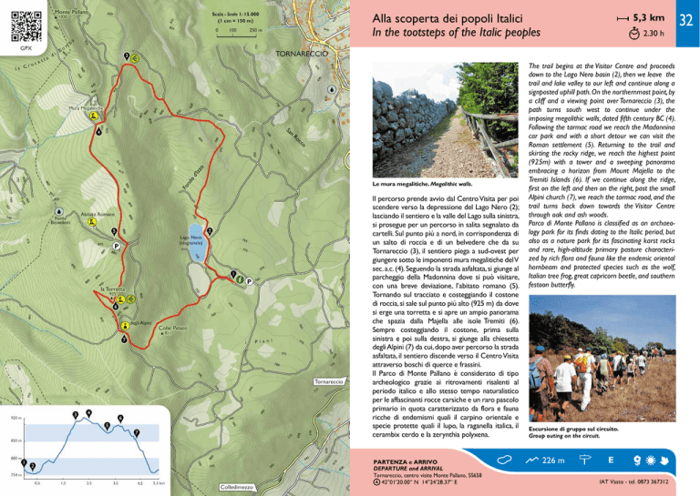
Il percorso prende avvio dal Centro Visita per poi
scendere verso la depressione del Lago Nero (2);
lasciando il sentiero e la valle del Lago sulla sinistra,
si prosegue per un percorso in salita segnalato da
cartelli. Sul punto più a nord, in corrispondenza di
un salto di roccia e di un belvedere che da su
Tornareccio (3), il sentiero piega a sud-ovest per
giungere sotto le imponenti mura megalitiche del V
sec. a.c. (4). Seguendo la strada asfaltata, si giunge al
parcheggio della Madonnina dove si può visitare,
con una breve deviazione, l’abitato romano (5).
Tornando sul tracciato e costeggiando il costone
di roccia, si sale sul punto più alto (925 m) da dove
si erge una torretta e si apre un ampio panorama
che spazia dalla Majella alle isole Tremiti (6).
Sempre costeggiando il costone, prima sulla
sinistra e poi sulla destra, si giunge alla chiesetta
degli Alpini (7) da cui, dopo aver percorso la strada
asfaltata, il sentiero discende verso il Centro Visita
attraverso boschi di querce e frassini.
Il Parco di Monte Pallano è considerato di tipo
archeologico grazie ai ritrovamenti risalenti al
periodo italico e allo stesso tempo naturalistico
per le affascinanti rocce carsiche e un raro pascolo
primario in quota caratterizzato da flora e fauna
ricche di endemismi quali il carpino orientale e
specie protette quali il lupo, la raganella italica, il
cerambix cerdo e la zerynthia polyxena.
PARTENZA e ARRIVO
DEPARTURE and ARRIVAL
Tornareccio, centro visite Monte Pallano, SS658
42°01’20.00’’ N 14°24’28.37’’ E
5,3 km
2.30 h
The trail begins at the Visitor Centre and proceeds
down to the Lago Nero basin (2), then we leave the
trail and lake valley to our left and continue along a
signposted uphill path. On the northernmost point, by
a cliff and a viewing point over Tornareccio (3), the
path turns south west to continue under the
imposing megalithic walls, dated fifth century BC (4).
Following the tarmac road we reach the Madonnina
car park and with a short detour we can visit the
Roman settlement (5). Returning to the trail and
skirting the rocky ridge, we reach the highest point
(925m) with a tower and a sweeping panorama
embracing a horizon from Mount Majella to the
Tremiti Islands (6). If we continue along the ridge,
first on the left and then on the right, past the small
Alpini church (7), we reach the tarmac road, and the
trail turns back down towards the Visitor Centre
through oak and ash woods.
Parco di Monte Pallano is classified as an archaeology park for its finds dating to the Italic period, but
also as a nature park for its fascinating karst rocks
and rare, high-altitude primary pasture characterized by rich flora and fauna like the endemic oriental
hornbeam and protected species such as the wolf,
Italian tree frog, great capricorn beetle, and southern
festoon butterfly.
Escursione di gruppo sul circuito.
Group outing on the circuit.
226 m
E
IAT Vasto - tel. 0873 367312
32

